
Mapa topográfico London
Mapa interactivo
Haga clic en el mapa para ver la altitud.
Acerca de este mapa
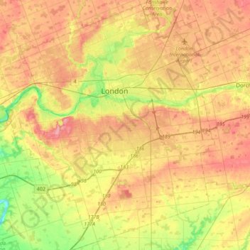
Nombre: Mapa topográfico London, altitud, relieve.
Lugar: London, Ontario, Canadá (42.82460 -81.39066 43.07305 -81.10708)
Altitud media: 264 m
Altitud mínima: 207 m
Altitud máxima: 315 m
Otros mapas topográficos
Haga clic en un mapa para ver su topografía, su altitud y su relieve.
Churchill
Canadá > Ontario > Simcoe County > Innisfil
Churchill, Innisfil, Simcoe County, Central Ontario, Ontario, L0L 1W0, Canadá
Altitud media: 262 m
Manitoulin Island
Canadá > Ontario > Northeastern Manitoulin and the Islands
Manitoulin Island, Northeastern Manitoulin and the Islands, Manitoulin District, Ontario, Canadá
Altitud media: 202 m
(Old) Ottawa
Canadá > Ontario > (Old) Ottawa
(Old) Ottawa, Ottawa, Eastern Ontario, Ontario, Canadá
Altitud media: 78 m
Grand River
Grand River, Wellington County, Southwestern Ontario, Ontario, N0B 2V0, Canadá
Altitud media: 300 m
Lake Simcoe
Lake Simcoe, Georgina, York Region, Golden Horseshoe, Ontario, L3Y 7C1, Canadá
Altitud media: 247 m
Windermere Lake
Canadá > Ontario > Unorganized South Nipissing
Windermere Lake, Unorganized South Nipissing, Nipissing District, Ontario, Canadá
Altitud media: 355 m
Lago de los Bosques
Canadá > Ontario > Lake of the Woods
Lago de los Bosques, Lake of the Woods, Rainy River District, Northwestern Ontario, Ontario, P0X 1C0, Canadá
Altitud media: 337 m
Lago Ontario
Canadá > Ontario > Quinte West
Lago Ontario, Quinte West, Central Ontario, Ontario, Canadá
Altitud media: 215 m