
Haz una donación
Mapa topográfico Kfar Him
Haga clic en el mapa para ver la altitud.
Haz una donación
Acerca de este mapa
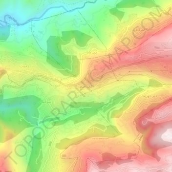
Nombre: Mapa topográfico Kfar Him, altitud, relieve.
Altitud media: 465 m
Altitud mínima: 57 m
Altitud máxima: 876 m
Haz una donación
Otros mapas topográficos
Haga clic en un mapa para ver su topografía, su altitud y su relieve.
Beit Mery
Lebanon > Mount Lebanon Governorate
1) Beit Mery I is on the right bank of the Beirut River, south southwest of the town at an altitude of approximately 125 metres (410 ft) above sea level. It was found by Jesuit Father Dillenseger who determined it to be an Acheulean site. The material was donated to the Saint Joseph University by the French…
Altitud media: 460 m
Haz una donación
Aley
Lebanon > Mount Lebanon Governorate
The word "Aley" means "high place" in Arabic and in Aramaic, referring to the city's high altitude above sea level (from 600m up to 950m).
Altitud media: 775 m
Haz una donación
Haz una donación
Haz una donación
Haz una donación
Haz una donación
Dik El Mehdeh
Lebanon > Mount Lebanon Governorate
Dik El Mehdi (Arabic: ديك المحدي) is a village, at 325 meters elevation, in the Matn District governorate of Mount Lebanon. Its population has been estimated at 2,096 by Aayroun. The village is around 18 km. from Beirut. The majority of it inhabitants derives from the Ashkar family. Many of its…
Altitud media: 246 m
Haz una donación
Haz una donación
Haz una donación
Haz una donación
Baskinta
Lebanon > Mount Lebanon Governorate
Baskinta (Arabic: بسكنتا) is a Lebanese village situated at an altitude ranging from 1250 metres above sea level and climbs up to approximately 1800 meters of height at Qanat Bakish, making it one of the highest villages of Lebanon. It is located 43 kilometers north east of Beirut.
Altitud media: 1,396 m
Haz una donación
Haz una donación
Haz una donación
Haz una donación
Haz una donación
Baskinta
Lebanon > Mount Lebanon Governorate
Baskinta (Arabic: بسكنتا) is a Lebanese village situated at an altitude ranging from 1250 metres above sea level and climbs up to approximately 1800 meters of height at Qanat Bakish, making it one of the highest villages of Lebanon. It is located 43 kilometers north east of Beirut.
Altitud media: 1,396 m
Haz una donación
Haz una donación
Haz una donación
Ain Saadeh
Lebanon > Mount Lebanon Governorate
The average annual rainfall is 825 millimetres (32.5 in), with the large majority of it falling from October to April. Much of the autumn and spring rain falls in heavy downpours on a limited number of days, but in winter it is spread more evenly over many days. Summer receives very little rainfall, if any.…
Altitud media: 335 m
Haz una donación
Antelias
Lebanon > Mount Lebanon Governorate
The municipality of Antelias - Naqqach is located in the Kaza of Matn in Mount Lebanon, one of the eight mohafazats (governorates) of Lebanon. Antelias - Naqqach is 8 kilometers (4.9712 mi) from Beyrouth (Beirut), the capital of Lebanon. Its elevation is 10 meters (32.81 ft; 10.936 yd) above sea level.…
Altitud media: 65 m
Haz una donación
Aley
Lebanon > Mount Lebanon Governorate
The word "Aley" means "high place" in Arabic and in Aramaic, referring to the city's high altitude above sea level (from 600m up to 950m).
Altitud media: 775 m
Haz una donación
Haz una donación
Haz una donación
Aley
Lebanon > Mount Lebanon Governorate
The word "Aley" means "high place" in Arabic and in Aramaic, referring to the city's high altitude above sea level (from 600m up to 950m).
Altitud media: 775 m