
Haz una donación
Mapa topográfico Sutton Bank
Haga clic en el mapa para ver la altitud.
Haz una donación
Acerca de este mapa
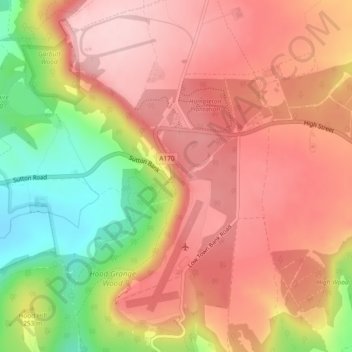
Nombre: Mapa topográfico Sutton Bank, altitud, relieve.
Altitud media: 240 m
Altitud mínima: 103 m
Altitud máxima: 323 m
Haz una donación
Otros mapas topográficos
Haga clic en un mapa para ver su topografía, su altitud y su relieve.
Haz una donación
Malton
United Kingdom > England > North Yorkshire
As with the rest of the British Isles and Yorkshire, Malton possesses a maritime climate with cool summers and mild winters. The nearest Met Office weather station for which records are available is High Mowthorpe, about 6 miles (10 km) east of the town centre. Due to its lower elevation, the town centre is…
Altitud media: 28 m
Haz una donación
Haz una donación
Haz una donación
Haz una donación
Howe
United Kingdom > England > North Yorkshire > Hambleton > Skipton on Swale > Howe
Altitud media: 28 m
Haz una donación
Craven
United Kingdom > England > North Yorkshire
Vegetation in the Pennines is adapted to subarctic climates, but altitude and acidity are also factors. For example, on Sutton Moor the millstone grit's topsoil below 275 m (902 ft) has a soil ph that is almost neutral, ph 6 to 7, and so grows good grazing. However, above 275 m (902 ft) it is acidic, ph 2 to…
Altitud media: 294 m
Exelby, Leeming and Londonderry
United Kingdom > England > North Yorkshire > Hambleton
Altitud media: 35 m
Haz una donación
Milby Cut
United Kingdom > England > North Yorkshire > Harrogate > Aldborough > Milby
Altitud media: 20 m
Haz una donación