
Haz una donación
Mapa topográfico Rowledge
Haga clic en el mapa para ver la altitud.
Haz una donación
Acerca de este mapa
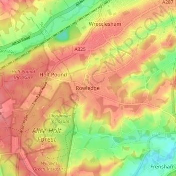
Nombre: Mapa topográfico Rowledge, altitud, relieve.
Lugar: Rowledge, Waverley, Surrey, England, GU10 4AR, United Kingdom (51.16341 -0.84226 51.20341 -0.80226)
Altitud media: 96 m
Altitud mínima: 52 m
Altitud máxima: 125 m
Haz una donación
Otros mapas topográficos
Haga clic en un mapa para ver su topografía, su altitud y su relieve.
Farnham
United Kingdom > England > Surrey > Waverley
Farnham lies in the valley of the North Branch of the River Wey, which rises near Alton, merges with the South Branch at Tilford, and joins the River Thames at Weybridge. The mainly east–west alignment of the ridges and valleys has influenced the development of road and rail communications. The most…
Altitud media: 100 m
Godalming
United Kingdom > England > Surrey > Waverley
Elevations vary between 36 m (118 ft) AOD by the Guildford Road Rugby Union ground and Broadwater lake at the River Wey's exit from Godalming into Peasmarsh, Shalford, and 106 m (348 ft) AOD where Quarter Mile meets Hambledon Road (both residential) in the south-east. Hurtmore Road is also residential: Upper…
Altitud media: 71 m