
Haz una donación
Mapa topográfico Semarang
Haga clic en el mapa para ver la altitud.
Haz una donación
Semarang
Semarang is located on the northern coast of Java. The city of Semarang is one of the important cities located on the north coast of Java and as the main hub connecting Jakarta and Surabaya, and cities in the southern interior of Java Surakarta and Yogyakarta. Semarang City has a height ranging from 2 m (6.6 ft) below sea level up to 340 m (1,120 ft) above sea level with a slope of 0%–45%. Semarang City is a city that has a unique topographic condition in the form of a narrow lowland area and hilly areas extending from the west side to the east side of Semarang City. The city is located about 558 km (347 mi) east of Jakarta and 312 km (194 mi) west of Surabaya.
Haz una donación
Acerca de este mapa
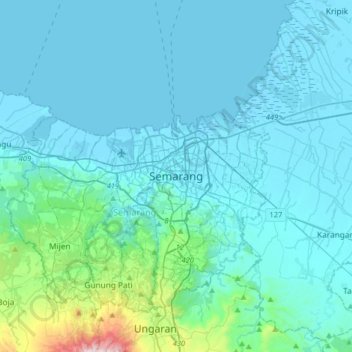
Nombre: Mapa topográfico Semarang, altitud, relieve.
Lugar: Semarang, Central Java, Java, Indonesia (-7.15040 110.26291 -6.83040 110.58291)
Altitud media: 88 m
Altitud mínima: -1 m
Altitud máxima: 971 m
Haz una donación
Otros mapas topográficos
Haga clic en un mapa para ver su topografía, su altitud y su relieve.
Semarang
Semarang is located on the northern coast of Java. The city of Semarang is one of the important cities located on the north coast of Java and as the main hub connecting Jakarta and Surabaya, and cities in the southern interior of Java Surakarta and Yogyakarta. Semarang City has a height ranging from 2 m (6.6…
Altitud media: 107 m
Haz una donación
Temanggung
Temanggung Regency is located on the volcanic Dieng Plateau with an average elevation between 500 and 1450 meters. It is landlocked. The volcanoes Mount Sundoro and Mount Sumbing rise on its border with the Wonosobo Regency. Its major drainage system is the Progo River and its tributaries.
Altitud media: 771 m
Haz una donación
Haz una donación
Purworejo
Railway in Purworejo is part of the southern Java railway system. Five train stations have served various areas in Purworejo. The primary station is Kutoarjo in Kutoarjo District. Located at an altitude of +16 meters, Kutoarjo Station is a large type A railway station that has seven (7) fully functioning lines…
Altitud media: 212 m
Wonosobo
Wonosobo has an elevation moderated tropical rainforest climate (Af) with moderate rainfall from July to September and heavy to very heavy rainfall in the remaining months. The following climate data is for the town of Wonosobo.
Altitud media: 876 m
Haz una donación
Haz una donación
Temanggung
Temanggung Regency is located on the volcanic Dieng Plateau with an average elevation between 500 and 1450 metres. It is landlocked. The volcanoes Mount Sundoro and Mount Sumbing rise on its border with the Wonosobo Regency. Its major drainage system is the Progo River and its tributaries.
Altitud media: 822 m
Haz una donación
Salatiga
Salatiga is located 48 km (30 mi) south of Semarang and 54 km (34 mi) north of Surakarta. Its elevation is between 450–800 metres. Salatiga has a tropical monsoon climate (Am) in the Köppen climate classification with the average rainfall of 2,668 mm (105.0 in) per year, the highest temperature in October…
Altitud media: 625 m
Haz una donación
Haz una donación
Haz una donación
Haz una donación
Alun-Alun Ambarawa
Indonesia > Central Java > Kabupaten Semarang > Tambakboyo > Katang
Altitud media: 499 m
Wonosobo
Wonosobo has an elevation moderated tropical rainforest climate (Af) with moderate rainfall from July to September and heavy to very heavy rainfall in the remaining months. The following climate data is for the town of Wonosobo.
Altitud media: 876 m
Haz una donación
Haz una donación
Salatiga
Salatiga is located 48 km (30 mi) south of Semarang and 54 km (34 mi) north of Surakarta. Its elevation is between 450–800 metres. Salatiga has a tropical monsoon climate (Am) in the Köppen climate classification with the average rainfall of 2,668 mm (105.0 in) per year, the highest temperature in October…
Altitud media: 625 m
Haz una donación
Semarang
Semarang is located on the northern coast of Java. The city of Semarang is one of the most important cities located on the north coast of Java and is the main hub connecting Jakarta and Surabaya, and cities in the southern interior of Java Surakarta and Yogyakarta. Semarang City has a height ranging from 2 m…
Altitud media: 107 m
Haz una donación
Gantangan Burung Bung Karno Dukuh Salatiga
Indonesia > Central Java > Salatiga > Dukuh > Glogolan
Altitud media: 599 m
Haz una donación
Haz una donación
Haz una donación
Rembang
It is a lowland, with a maximum elevation of about 70 metres (230 ft) above sea level.
Altitud media: 75 m
Salatiga
Salatiga is located 48 km (30 mi) south of Semarang and 54 km (34 mi) north of Surakarta. Its elevation is between 450–800 metres. Salatiga has a tropical monsoon climate (Am) in the Köppen climate classification with the average rainfall of 2,668 mm (105.0 in) per year, the highest temperature in October…
Altitud media: 625 m
Haz una donación
Semarang
Semarang is located on the northern coast of Java. The city of Semarang is one of the most important cities located on the north coast of Java and is the main hub connecting Jakarta and Surabaya, and cities in the southern interior of Java Surakarta and Yogyakarta. Semarang City has a height ranging from 2 m…
Altitud media: 107 m
Haz una donación
Haz una donación
Semarang
Semarang is located on the northern coast of Java. The city of Semarang is one of the most important cities located on the north coast of Java and is the main hub connecting Jakarta and Surabaya, and cities in the southern interior of Java Surakarta and Yogyakarta. Semarang City has a height ranging from 2 m…
Altitud media: 107 m
Haz una donación
Lapangan Paripurno Kecamatan Salaman
Indonesia > Central Java > Magelang > Kembanglimus
Altitud media: 276 m
Haz una donación
Haz una donación
Haz una donación
Salatiga
Salatiga is located 48 km (30 mi) south of Semarang and 54 km (34 mi) north of Surakarta. Its elevation is between 450–800 metres. Salatiga has a tropical monsoon climate (Am) in the Köppen climate classification with the average rainfall of 2,668 mm (105.0 in) per year, the highest temperature in October…
Altitud media: 625 m
Haz una donación