
Haz una donación
Mapa topográfico Beacon Rock
Haga clic en el mapa para ver la altitud.
Haz una donación
Acerca de este mapa
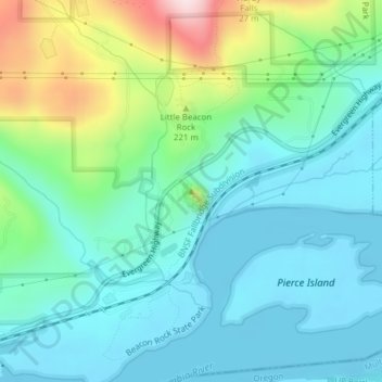
Nombre: Mapa topográfico Beacon Rock, altitud, relieve.
Altitud media: 93 m
Altitud mínima: -1 m
Altitud máxima: 386 m
Haz una donación
Otros mapas topográficos
Haga clic en un mapa para ver su topografía, su altitud y su relieve.
Gifford Pinchot National Forest
United States > Washington > Skamania County
Gifford Pinchot National Forest is located in a mountainous region approximately between Mount St. Helens to the west, Mount Adams to the east, Mount Rainier National Park to the north, and the Columbia River to the south. This region of Southwest Washington is noted for its complex topography and volcanic…
Altitud media: 769 m
Spirit Lake
United States > Washington > Skamania County
Prior to 1980, Spirit Lake consisted of two arms that occupied what had been the valleys of the North Fork Toutle River and a tributary. About 4,000 years ago, these valleys were blocked by lahars and pyroclastic flow deposits from Mount St. Helens to form the pre-1980 Spirit Lake. The longest branch of Spirit…
Altitud media: 1,144 m
Haz una donación