
Gracias por apoyar a este sitio ❤️
Haz una donación
Haz una donación
Mapa topográfico Thorpe
Haga clic en el mapa para ver la altitud.
Gracias por apoyar a este sitio ❤️
Haz una donación
Haz una donación
Thorpe
Elevations are modest but not flat, ranging between 14 and 20m Ordnance Datum as much of the area lies on thin alluvium overlying gravel beds laid over millennia by the River Thames which adjoins the traditional parish to the east.
Gracias por apoyar a este sitio ❤️
Haz una donación
Haz una donación
Acerca de este mapa
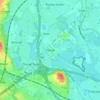
Nombre: Mapa topográfico Thorpe, altitud, relieve.
Altitud media: 19 m
Altitud mínima: 8 m
Altitud máxima: 71 m
Gracias por apoyar a este sitio ❤️
Haz una donación
Haz una donación