
Haz una donación
Mapa topográfico Type
Haga clic en el mapa para ver la altitud.
Haz una donación
Acerca de este mapa
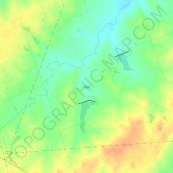
Nombre: Mapa topográfico Type, altitud, relieve.
Lugar: Type, Williamson County, Texas, United States (30.41238 -97.35874 30.45238 -97.31874)
Altitud media: 174 m
Altitud mínima: 156 m
Altitud máxima: 192 m
Haz una donación
Otros mapas topográficos
Haga clic en un mapa para ver su topografía, su altitud y su relieve.
Soil Conservation Service Site 12 Dam
United States > Texas > Williamson County > Type
Altitud media: 173 m
Haz una donación
Georgetown
United States > Texas > Williamson County > Georgetown
The city is located on the northeastern edge of Texas Hill Country. Portions of Georgetown are located on either side of the Balcones Escarpment, a fault line in which the areas roughly east of IH-35 are flat and characterized by having black, fertile soils of the Blackland Prairie, and the west side of the…
Altitud media: 219 m
Haz una donación